
Make a donation
Gear up for your next adventure:
As an Amazon Associate, this site earns from qualifying purchases at no extra cost to you.
Mondsee topographic map
Click on the map to display elevation.
Make a donation
Gear up for your next adventure:
As an Amazon Associate, this site earns from qualifying purchases at no extra cost to you.
Mondsee
Der Ort liegt auf 493 m Höhe im Hausruckviertel am Mondsee. Die Ausdehnung beträgt von Nord nach Süd 9,5 km, von West nach Ost 7,7 km. Die Gesamtfläche beträgt 16,4 km², 0,6 % der Fläche sind bewaldet, 7,3 % der Fläche sind landwirtschaftlich genutzt, 83 % der Fläche nimmt der Mondsee ein.
Make a donation
Gear up for your next adventure:
As an Amazon Associate, this site earns from qualifying purchases at no extra cost to you.
About this map
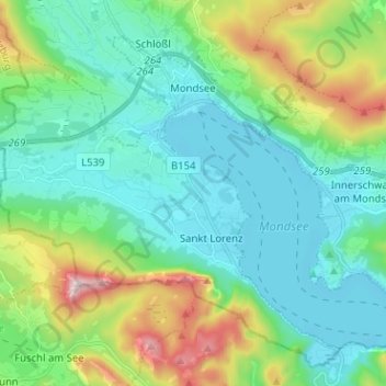
Name: Mondsee topographic map, elevation, terrain.
Location: Mondsee, Bezirk Vöcklabruck, Oberösterreich, 5310, Österreich (47.79789 13.32371 47.86747 13.45061)
Average elevation: 666 m
Minimum elevation: 473 m
Maximum elevation: 1,284 m
Make a donation
Gear up for your next adventure:
As an Amazon Associate, this site earns from qualifying purchases at no extra cost to you.
Other topographic maps
Click on a map to view its topography, its elevation and its terrain.
Ackersberg
Österreich > Oberösterreich > Bezirk Vöcklabruck > Neukirchen an der Vöckla
Average elevation: 589 m
Make a donation
Gear up for your next adventure:
As an Amazon Associate, this site earns from qualifying purchases at no extra cost to you.
Make a donation
Gear up for your next adventure:
As an Amazon Associate, this site earns from qualifying purchases at no extra cost to you.
Make a donation
Gear up for your next adventure:
As an Amazon Associate, this site earns from qualifying purchases at no extra cost to you.
Badstuben
Österreich > Oberösterreich > Bezirk Vöcklabruck > Frankenburg am Hausruck
Average elevation: 619 m
Make a donation
Gear up for your next adventure:
As an Amazon Associate, this site earns from qualifying purchases at no extra cost to you.
Aussichtsturm Göblberg
Österreich > Oberösterreich > Bezirk Vöcklabruck > Ampflwang im Hausruckwald
Average elevation: 680 m
Innerlohen
Österreich > Oberösterreich > Bezirk Vöcklabruck > Wildenhag im Attergau
Average elevation: 586 m
Neubrunn
Österreich > Oberösterreich > Bezirk Vöcklabruck > Seewalchen am Attersee
Average elevation: 499 m
Make a donation
Gear up for your next adventure:
As an Amazon Associate, this site earns from qualifying purchases at no extra cost to you.
Niederpuchheim
Österreich > Oberösterreich > Bezirk Vöcklabruck > Ottnang am Hausruck
Average elevation: 596 m
Unterthumberg
Österreich > Oberösterreich > Bezirk Vöcklabruck > Neukirchen an der Vöckla
Average elevation: 485 m
Hoblschlag
Österreich > Oberösterreich > Bezirk Vöcklabruck > Frankenburg am Hausruck
Average elevation: 656 m
Rothauptberg
Österreich > Oberösterreich > Bezirk Vöcklabruck > Neukirchen an der Vöckla
Average elevation: 652 m
Make a donation
Gear up for your next adventure:
As an Amazon Associate, this site earns from qualifying purchases at no extra cost to you.
Steinwand
Österreich > Oberösterreich > Bezirk Vöcklabruck > Weißenkirchen im Attergau > Steinwand
Average elevation: 576 m
Achleithen
Österreich > Oberösterreich > Bezirk Vöcklabruck > Ottnang am Hausruck
Average elevation: 537 m
Make a donation
Gear up for your next adventure:
As an Amazon Associate, this site earns from qualifying purchases at no extra cost to you.