
Jajce topographic map
Interactive map
Click on the map to display elevation.
About this map
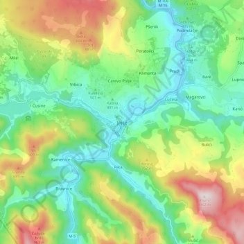
Name: Jajce topographic map, elevation, terrain.
Average elevation: 607 m
Minimum elevation: 331 m
Maximum elevation: 1,139 m
Other topographic maps
Click on a map to view its topography, its elevation and its terrain.
Mostar
Bosnia and Herzegovina > Federation of Bosnia and Herzegovina > City of Mostar
Average elevation: 221 m
City of Sarajevo
Bosnia and Herzegovina > Federation of Bosnia and Herzegovina
Average elevation: 810 m