
Make a donation
Gear up for your next adventure:
As an Amazon Associate, this site earns from qualifying purchases at no extra cost to you.
Widderstein topographic map
Click on the map to display elevation.
Make a donation
Gear up for your next adventure:
As an Amazon Associate, this site earns from qualifying purchases at no extra cost to you.
Widderstein
Der Widderstein (auch Großer Widderstein) ist ein 2533 m ü. A. hoher Berg in Vorarlberg im westlichen Österreich. Topografisch gehört er zu den Südöstlichen Walsertaler Bergen der Allgäuer Alpen. Er ist der höchste Berg dieser Gruppe.
Make a donation
Gear up for your next adventure:
As an Amazon Associate, this site earns from qualifying purchases at no extra cost to you.
About this map
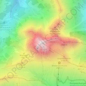
Name: Widderstein topographic map, elevation, terrain.
Average elevation: 1,845 m
Minimum elevation: 1,316 m
Maximum elevation: 2,514 m
Make a donation
Gear up for your next adventure:
As an Amazon Associate, this site earns from qualifying purchases at no extra cost to you.
Other topographic maps
Click on a map to view its topography, its elevation and its terrain.