
Clallam County topographic map
Interactive map
Click on the map to display elevation.
About this map
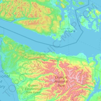
Name: Clallam County topographic map, elevation, terrain.
Location: Clallam County, Washington, United States of America (47.86668 -124.83609 48.49344 -122.89716)
Average elevation: 335 m
Minimum elevation: -2 m
Maximum elevation: 2,383 m
Other topographic maps
Click on a map to view its topography, its elevation and its terrain.
Lake Morton-Berrydale
United States of America > Washington > Lake Morton-Berrydale
Lake Morton-Berrydale, King County, Washington, United States of America
Average elevation: 132 m
Redmond
United States of America > Washington > Redmond
Redmond, King County, Washington, United States of America
Average elevation: 72 m
Lewis County
United States of America > Washington
Lewis County, Washington, United States of America
Average elevation: 558 m
Okanogan County
United States of America > Washington > Okanogan County
Okanogan County, Washington, United States of America
Average elevation: 1,076 m
Yakima County
United States of America > Washington
Yakima County, Washington, United States of America
Average elevation: 879 m
Island County
United States of America > Washington
Island County, Washington, United States of America
Average elevation: 98 m