
Church Stretton topographic map
Interactive map
Click on the map to display elevation.
About this map
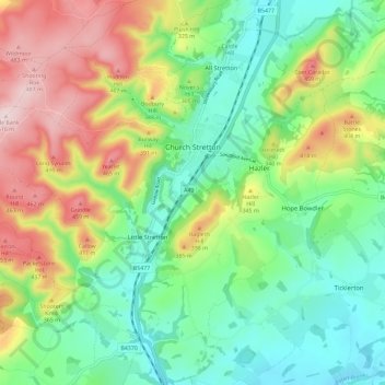
Name: Church Stretton topographic map, elevation, terrain.
Location: Church Stretton, Shropshire, England, Vereinigtes Königreich (52.49558 -2.87889 52.56571 -2.76700)
Average elevation: 280 m
Minimum elevation: 146 m
Maximum elevation: 513 m
Other topographic maps
Click on a map to view its topography, its elevation and its terrain.
Ragdon
Vereinigtes Königreich > England > Shropshire > Hope Bowdler
Ragdon, Hope Bowdler, Shropshire, England, SY6 7EZ, Vereinigtes Königreich
Average elevation: 234 m
Grindle
Vereinigtes Königreich > England > Shropshire > Church Stretton
Grindle, Church Stretton, Shropshire, England, SY6 6PW, Vereinigtes Königreich
Average elevation: 349 m
Ludlow
Vereinigtes Königreich > England > Shropshire
Ludlow, Shropshire, England, Vereinigtes Königreich
Average elevation: 108 m
Donington
Vereinigtes Königreich > England > Shropshire > Donington
Donington, Shropshire, West Midlands, England, Vereinigtes Königreich
Average elevation: 100 m