
Make a donation
Gear up for your next adventure:
As an Amazon Associate, this site earns from qualifying purchases at no extra cost to you.
Sharon topographic map
Click on the map to display elevation.
Make a donation
Gear up for your next adventure:
As an Amazon Associate, this site earns from qualifying purchases at no extra cost to you.
About this map
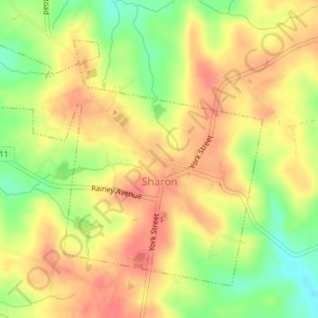
Name: Sharon topographic map, elevation, terrain.
Location: Sharon, York County, South Carolina, United States (34.94207 -81.36059 34.96364 -81.33022)
Average elevation: 183 m
Minimum elevation: 147 m
Maximum elevation: 206 m
Make a donation
Gear up for your next adventure:
As an Amazon Associate, this site earns from qualifying purchases at no extra cost to you.
Other topographic maps
Click on a map to view its topography, its elevation and its terrain.
Make a donation
Gear up for your next adventure:
As an Amazon Associate, this site earns from qualifying purchases at no extra cost to you.
Boyd Hill
United States > South Carolina > York County > Rock Hill > Boyd Hill
Average elevation: 192 m
Rock Hill
United States > South Carolina > York County > Rock Hill > Rock Hill
Average elevation: 185 m