Geolocate

Livingston topographic map

Click on the map to display elevation.

About this map
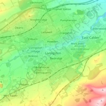
Name: Livingston topographic map, elevation, terrain.

Location: Livingston, West Lothian, Scotland, EH54 6GS, United Kingdom (55.84296 -3.55758 55.92296 -3.47758)

Average elevation: 158 m

Minimum elevation: 69 m

Maximum elevation: 352 m

Other topographic maps

Click on a map to view its topography, its elevation and its terrain.

Deans

United Kingdom > Scotland > West Lothian

Average elevation: 164 m

River Almond

United Kingdom > Scotland > West Lothian

Average elevation: 162 m

Dechmont

United Kingdom > Scotland > West Lothian

Average elevation: 155 m

Whispering Wood

United Kingdom > Scotland > West Lothian > Deans

Average elevation: 166 m

Gear up for your next adventure:

🧤Thermal Outdoor Gloves - Windproof and waterproof gloves for winter hiking
🛍️Outdoor Accessory Kits - Bundles for new hikers
🔌Travel Adapters - Essential for visitors to charge gear in Ireland
🧭Sighting Compasses - Professional grade mirror compass for precise orientation
🪵Fire Starters & Tools - Tools to start fire in wet conditions

As an Amazon Associate, this site earns from qualifying purchases at no extra cost to you.