Geolocate

Lewes topographic map

Click on the map to display elevation.

About this map
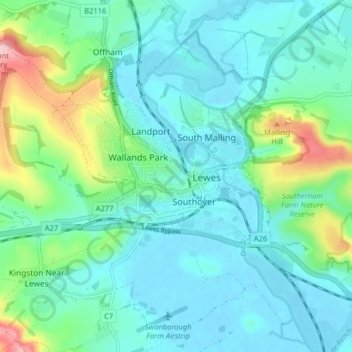
Name: Lewes topographic map, elevation, terrain.

Location: Lewes, East Sussex, England, United Kingdom (50.85948 -0.03090 50.88925 0.04931)

Average elevation: 36 m

Minimum elevation: -2 m

Maximum elevation: 164 m

Other topographic maps

Click on a map to view its topography, its elevation and its terrain.
Seven Sisters

United Kingdom > England > East Sussex > Wealden > Friston

Average elevation: 35 m

East Hoathly

United Kingdom > England > East Sussex > Wealden

Average elevation: 52 m

Blackham

United Kingdom > England > East Sussex > Wealden

Average elevation: 72 m

Gear up for your next adventure:

🎒Fully Waterproof Rucksacks - Submersible protection for river crossings
🫗Collapsible Water Bottles - Space‑saving hydration
🩹Compact First Aid Kits - Treat blisters and minor injuries on the trail
🥘Camping Cookware Sets - Cookware sets for backpacking meals
🚰Hydration Packs - Hands‑free water storage for hikers

As an Amazon Associate, this site earns from qualifying purchases at no extra cost to you.