
Lewes topographic map
Click on the map to display elevation.
About this map
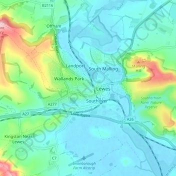
Name: Lewes topographic map, elevation, terrain.
Location: Lewes, East Sussex, England, United Kingdom (50.85948 -0.03090 50.88925 0.04931)
Average elevation: 36 m
Minimum elevation: -2 m
Maximum elevation: 164 m
Other topographic maps
Click on a map to view its topography, its elevation and its terrain.
Speckled Wood, Hastings
United Kingdom > England > East Sussex > Hastings
The Upper Ore Valley to date has steep sixty-degree valleys or inclines to the north, east and west. The stream cuts right through the lower valley exposing the Ashdown bed in sections along the valley floor. To the west the incline falls off to a plateau which then rises to land level. The North End of the…
Average elevation: 92 m