Geolocate

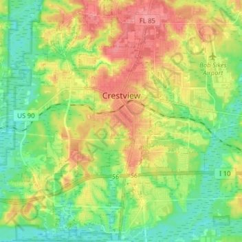
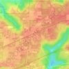
Crestview topographic map

Click on the map to display elevation.

Crestview

Crestview is the largest city and county seat of Okaloosa County, Florida, United States. The population was 27,134 at the 2020 census, up from 20,978 at the 2010 census. With an elevation of 236 feet (72 m) above sea level, it is one of the highest points in the state.

Wikipedia (CC-BY-SA 3.0)

About this map

Name: Crestview topographic map, elevation, terrain.

Location: Crestview, Okaloosa County, Florida, United States (30.69569 -86.63562 30.80514 -86.52671)

Average elevation: 43 m

Minimum elevation: 10 m

Maximum elevation: 89 m

Other topographic maps

Click on a map to view its topography, its elevation and its terrain.

Galliver

United States > Florida > Okaloosa County

Average elevation: 54 m

Deerland

United States > Florida > Okaloosa County

Average elevation: 63 m

Holt

United States > Florida > Okaloosa County

Average elevation: 53 m

Holt

United States > Florida > Okaloosa County

Average elevation: 53 m

Gear up for your next adventure:

📡Satellite Messengers - Emergency communication for remote areas without signal
🍁Eco‑Friendly Outdoor Products - Sustainable outdoor gear
🎒Fully Waterproof Rucksacks - Submersible protection for river crossings
🍴Camp Kitchen Kits - Lightweight nesting pots and pans for backpacking
🔦High-Lumen Headlamps - Hands-free lighting for early starts or late finishes

As an Amazon Associate, this site earns from qualifying purchases at no extra cost to you.