
Make a donation
Gear up for your next adventure:
As an Amazon Associate, this site earns from qualifying purchases at no extra cost to you.
Herten topographic map
Click on the map to display elevation.
Make a donation
Gear up for your next adventure:
As an Amazon Associate, this site earns from qualifying purchases at no extra cost to you.
Herten
Herten covers an area of 37.31 km2, with a maximum north-south extent of 9.5 km, and a maximum east-west extent of 6.5 km. The municipality's highest natural point is in Scherlebeck, close to the border with Recklinghausen, with an altitude of 110 m.
Make a donation
Gear up for your next adventure:
As an Amazon Associate, this site earns from qualifying purchases at no extra cost to you.
About this map
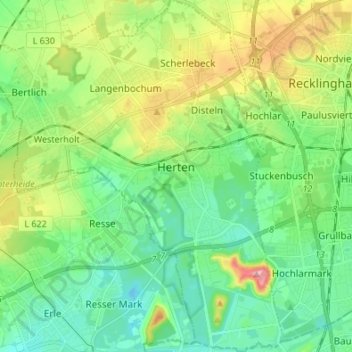
Name: Herten topographic map, elevation, terrain.
Location: Herten, Kreis Recklinghausen, North Rhine-Westphalia, Germany (51.55004 7.06661 51.63416 7.17970)
Average elevation: 68 m
Minimum elevation: 29 m
Maximum elevation: 152 m
Make a donation
Gear up for your next adventure:
As an Amazon Associate, this site earns from qualifying purchases at no extra cost to you.
Other topographic maps
Click on a map to view its topography, its elevation and its terrain.
Holtwick
Germany > North Rhine-Westphalia > Kreis Recklinghausen > Haltern am See
Average elevation: 89 m
Sythen
Germany > North Rhine-Westphalia > Kreis Recklinghausen > Haltern am See
Average elevation: 54 m