
Make a donation
Gear up for your next adventure:
As an Amazon Associate, this site earns from qualifying purchases at no extra cost to you.
Monagas State topographic map
Click on the map to display elevation.
Make a donation
Gear up for your next adventure:
As an Amazon Associate, this site earns from qualifying purchases at no extra cost to you.
Monagas State
The state has many plateaus and savannas located in the southwest. In the northeast and the southeast there are deltaic savannas in which rivers such as the San Juan, Guanipa, Caño Mánamo, and Tigre flow into. In the northwest is a group of mountains belonging to the eastern mountain range. This mountain range is divided into two massifs: the massif of el Turimiquire (in which the town of San Antonio is located) and the massif of Caripe (in which the town of Caripe is located). Cerro Negro (2000 m.) is the highest mountain of Monagas State. The mountain landscape features geological material from the Cretaceous, constituted exclusively by sedimentary rocks, predominantly sandstone, shale and limestone, with the main geological formations being El Cantil, Barranquín, Guayuta and Querecual; it has elevations between 400 and 2,300 m (1,300 and 7,500 ft) above sea level, with valleys and depressions.
Make a donation
Gear up for your next adventure:
As an Amazon Associate, this site earns from qualifying purchases at no extra cost to you.
About this map
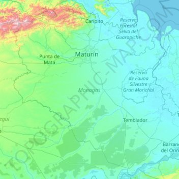
Name: Monagas State topographic map, elevation, terrain.
Location: Monagas State, Venezuela (8.38241 -64.01850 10.30526 -61.99433)
Average elevation: 164 m
Minimum elevation: -1 m
Maximum elevation: 2,480 m
Make a donation
Gear up for your next adventure:
As an Amazon Associate, this site earns from qualifying purchases at no extra cost to you.
Other topographic maps
Click on a map to view its topography, its elevation and its terrain.