
Thank you for supporting this site ❤️
Make a donation
Make a donation
Gear up for your next adventure:
As an Amazon Associate, this site earns from qualifying purchases at no extra cost to you.
Steinwiesen topographic map
Click on the map to display elevation.
Thank you for supporting this site ❤️
Make a donation
Make a donation
Gear up for your next adventure:
As an Amazon Associate, this site earns from qualifying purchases at no extra cost to you.
About this map
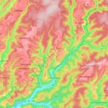
Name: Steinwiesen topographic map, elevation, terrain.
Location: Steinwiesen, Landkreis Kronach, Bavaria, 96349, Germany (50.27833 11.39641 50.36035 11.54117)
Average elevation: 516 m
Minimum elevation: 341 m
Maximum elevation: 650 m
Thank you for supporting this site ❤️
Make a donation
Make a donation
Gear up for your next adventure:
As an Amazon Associate, this site earns from qualifying purchases at no extra cost to you.