
Make a donation
Gear up for your next adventure:
As an Amazon Associate, this site earns from qualifying purchases at no extra cost to you.
Bamfield topographic map
Click on the map to display elevation.
Make a donation
Gear up for your next adventure:
As an Amazon Associate, this site earns from qualifying purchases at no extra cost to you.
About this map
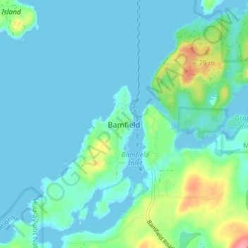
Name: Bamfield topographic map, elevation, terrain.
Average elevation: 16 m
Minimum elevation: -1 m
Maximum elevation: 92 m
Make a donation
Gear up for your next adventure:
As an Amazon Associate, this site earns from qualifying purchases at no extra cost to you.
Other topographic maps
Click on a map to view its topography, its elevation and its terrain.
Alberni Inlet
Canada > British Columbia > Alberni-Clayoquot Regional District > Area A (Bamfield)
Average elevation: 465 m
Seabird Rocks
Canada > British Columbia > Alberni-Clayoquot Regional District > Area A (Bamfield)
Average elevation: 0 m
Snug Basin
Canada > British Columbia > Alberni-Clayoquot Regional District > Area A (Bamfield)
Average elevation: 103 m