
Make a donation
Gear up for your next adventure:
As an Amazon Associate, this site earns from qualifying purchases at no extra cost to you.
Sierra Negra topographic map
Click on the map to display elevation.
Make a donation
Gear up for your next adventure:
As an Amazon Associate, this site earns from qualifying purchases at no extra cost to you.
Sierra Negra
Sierra Negra is located within the Pico de Orizaba National Park. The mountain is the site for two of the world's premier astronomical instruments, the Large Millimeter Telescope and the High Altitude Water Cherenkov Observatory. Therefore, the access to the mountain is restricted and has to be applied for at least a week in advance. The service road for this facility is claimed to be the highest road in North America. A part of the telescope facility is visible as a white dot in the first picture below and more clearly in the second picture.
Make a donation
Gear up for your next adventure:
As an Amazon Associate, this site earns from qualifying purchases at no extra cost to you.
About this map
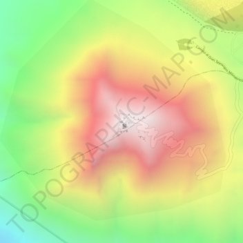
Name: Sierra Negra topographic map, elevation, terrain.
Location: Sierra Negra, Chalchicomula de Sesma, Puebla, Mexico (18.98616 -97.31515 18.98626 -97.31505)
Average elevation: 4,099 m
Minimum elevation: 3,534 m
Maximum elevation: 4,575 m
Make a donation
Gear up for your next adventure:
As an Amazon Associate, this site earns from qualifying purchases at no extra cost to you.