
Make a donation
Gear up for your next adventure:
As an Amazon Associate, this site earns from qualifying purchases at no extra cost to you.
Masca topographic map
Click on the map to display elevation.
Make a donation
Gear up for your next adventure:
As an Amazon Associate, this site earns from qualifying purchases at no extra cost to you.
Masca
Masca is a small mountain village on the island of Tenerife. It was originally a Guanche settlement before the Spanish conquest in 1496. The village is now home to around 90 inhabitants. The village lies at an altitude of 650 m in the Macizo de Teno mountains, which extend up to the northwesternmost point of Tenerife.
Make a donation
Gear up for your next adventure:
As an Amazon Associate, this site earns from qualifying purchases at no extra cost to you.
About this map
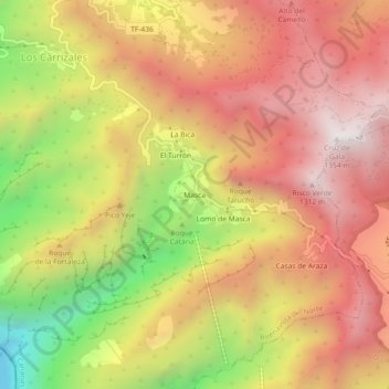
Name: Masca topographic map, elevation, terrain.
Average elevation: 769 m
Minimum elevation: 0 m
Maximum elevation: 1,311 m
Make a donation
Gear up for your next adventure:
As an Amazon Associate, this site earns from qualifying purchases at no extra cost to you.