
Laurierville topographic map
Interactive map
Click on the map to display elevation.
About this map
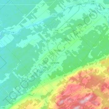
Name: Laurierville topographic map, elevation, terrain.
Location: Laurierville, L'Érable, Centre-du-Québec, Quebec, Canada (46.23653 -71.78925 46.37625 -71.58962)
Average elevation: 171 m
Minimum elevation: 115 m
Maximum elevation: 344 m
Other topographic maps
Click on a map to view its topography, its elevation and its terrain.
Plessisville (ville)
Plessisville (ville), L'Érable, Centre-du-Québec, Quebec, Canada
Average elevation: 153 m
Saint-Ferdinand
Saint-Ferdinand, L'Érable, Centre-du-Québec, Quebec, G0N 1N0, Canada
Average elevation: 346 m