
Montpouillan topographic map
Interactive map
Click on the map to display elevation.
About this map
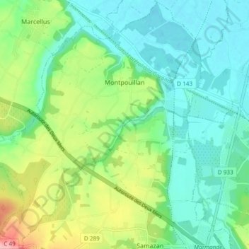
Name: Montpouillan topographic map, elevation, terrain.
Average elevation: 52 m
Minimum elevation: 17 m
Maximum elevation: 138 m
Other topographic maps
Click on a map to view its topography, its elevation and its terrain.
Caumont-sur-Garonne
France > Nouvelle-Aquitaine > Lot-et-Garonne
Caumont-sur-Garonne, Marmande, Lot-et-Garonne, Nouvelle-Aquitaine, Metropolitan France, 47430, France
Average elevation: 62 m
Castelculier
France > Nouvelle-Aquitaine > Lot-et-Garonne
Castelculier, Agen, Lot-et-Garonne, Nouvelle-Aquitaine, Metropolitan France, 47240, France
Average elevation: 97 m
Saint-Étienne-de-Fougères
France > Nouvelle-Aquitaine > Lot-et-Garonne
Saint-Étienne-de-Fougères, Villeneuve-sur-Lot, Lot-et-Garonne, Nouvelle-Aquitaine, Metropolitan France, 47380, France
Average elevation: 54 m
Bruch
France > Nouvelle-Aquitaine > Lot-et-Garonne
Bruch, Nérac, Lot-et-Garonne, Nouvelle-Aquitaine, Metropolitan France, 47130, France
Average elevation: 73 m
Sous Chays
France > Nouvelle-Aquitaine > Lot-et-Garonne > Pujols
Sous Chays, Pujols, Villeneuve-sur-Lot, Lot-et-Garonne, Nouvelle-Aquitaine, Metropolitan France, 47300, France
Average elevation: 102 m
Buzet-sur-Baïse
France > Nouvelle-Aquitaine > Lot-et-Garonne
Buzet-sur-Baïse, Nérac, Lot-et-Garonne, Nouvelle-Aquitaine, Metropolitan France, 47160, France
Average elevation: 70 m
Château de Dolmayrac
France > Nouvelle-Aquitaine > Lot-et-Garonne > Dolmayrac
Château de Dolmayrac, Place de la Tour, Delcros, Dolmayrac, Villeneuve-sur-Lot, Lot-et-Garonne, Nouvelle-Aquitaine, Metropolitan France, 47110, France
Average elevation: 128 m
Saint-Arnaud
France > Nouvelle-Aquitaine > Lot-et-Garonne > Bajamont
Saint-Arnaud, Bajamont, Agen, Lot-et-Garonne, Nouvelle-Aquitaine, Metropolitan France, 47480, France
Average elevation: 142 m
Bonneval
France > Nouvelle-Aquitaine > Lot-et-Garonne > Hautefage-la-Tour
Bonneval, Hautefage-la-Tour, Villeneuve-sur-Lot, Lot-et-Garonne, Nouvelle-Aquitaine, Metropolitan France, 47340, France
Average elevation: 157 m
Nérac
France > Nouvelle-Aquitaine > Lot-et-Garonne
Nérac, Lot-et-Garonne, Nouvelle-Aquitaine, Metropolitan France, 47600, France
Average elevation: 103 m
Lavergne
France > Nouvelle-Aquitaine > Lot-et-Garonne
Lavergne, Marmande, Lot-et-Garonne, Nouvelle-Aquitaine, Metropolitan France, 47800, France
Average elevation: 82 m
Le Passage
France > Nouvelle-Aquitaine > Lot-et-Garonne
Le Passage, Agen, Lot-et-Garonne, Nouvelle-Aquitaine, Metropolitan France, 47520, France
Average elevation: 61 m
Saint-Jean
France > Nouvelle-Aquitaine > Lot-et-Garonne > Montpouillan
Saint-Jean, Montpouillan, Marmande, Lot-et-Garonne, Nouvelle-Aquitaine, Metropolitan France, 47200, France
Average elevation: 47 m
Fargues-sur-Ourbise
France > Nouvelle-Aquitaine > Lot-et-Garonne
Fargues-sur-Ourbise, Nérac, Lot-et-Garonne, Nouvelle-Aquitaine, Metropolitan France, 47700, France
Average elevation: 121 m
Montpezat
France > Nouvelle-Aquitaine > Lot-et-Garonne
Montpezat, Agen, Lot-et-Garonne, Nouvelle-Aquitaine, Metropolitan France, 47360, France
Average elevation: 104 m
Francescas
France > Nouvelle-Aquitaine > Lot-et-Garonne
Francescas, Nérac, Lot-et-Garonne, Nouvelle-Aquitaine, Metropolitan France, 47600, France
Average elevation: 113 m
Villeneuve-sur-Lot
France > Nouvelle-Aquitaine > Lot-et-Garonne
Villeneuve-sur-Lot, Lot-et-Garonne, Nouvelle-Aquitaine, Metropolitan France, 47300, France
Average elevation: 99 m
Gontaud-de-Nogaret
France > Nouvelle-Aquitaine > Lot-et-Garonne
Gontaud-de-Nogaret, Marmande, Lot-et-Garonne, Nouvelle-Aquitaine, Metropolitan France, 47400, France
Average elevation: 62 m
Saint-Léger
France > Nouvelle-Aquitaine > Lot-et-Garonne > Saint-Léger
Saint-Léger, Nérac, Lot-et-Garonne, Nouvelle-Aquitaine, Metropolitan France, 47160, France
Average elevation: 33 m
Bissières
France > Nouvelle-Aquitaine > Lot-et-Garonne > Sainte-Colombe-de-Villeneuve
Bissières, Sainte-Colombe-de-Villeneuve, Villeneuve-sur-Lot, Lot-et-Garonne, Nouvelle-Aquitaine, Metropolitan France, 47300, France
Average elevation: 161 m
Lacépède
France > Nouvelle-Aquitaine > Lot-et-Garonne
Lacépède, Agen, Lot-et-Garonne, Nouvelle-Aquitaine, Metropolitan France, 47360, France
Average elevation: 107 m
Tournon-d'Agenais
France > Nouvelle-Aquitaine > Lot-et-Garonne
Tournon-d'Agenais, Villeneuve-sur-Lot, Lot-et-Garonne, Nouvelle-Aquitaine, Metropolitan France, 47370, France
Average elevation: 184 m
Sainte-Livrade-sur-Lot
France > Nouvelle-Aquitaine > Lot-et-Garonne
Sainte-Livrade-sur-Lot, Villeneuve-sur-Lot, Lot-et-Garonne, Nouvelle-Aquitaine, Metropolitan France, 47110, France
Average elevation: 72 m
Nicole
France > Nouvelle-Aquitaine > Lot-et-Garonne
Nicole, Agen, Lot-et-Garonne, Nouvelle-Aquitaine, Metropolitan France, 47190, France
Average elevation: 62 m
Pinel-Hauterive
France > Nouvelle-Aquitaine > Lot-et-Garonne
Pinel-Hauterive, Villeneuve-sur-Lot, Lot-et-Garonne, Nouvelle-Aquitaine, Metropolitan France, 47380, France
Average elevation: 105 m