
Umlazi topographic map
Interactive map
Click on the map to display elevation.
About this map
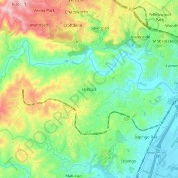
Name: Umlazi topographic map, elevation, terrain.
Average elevation: 100 m
Minimum elevation: 3 m
Maximum elevation: 284 m
Umlazi is approximately 15 kilometres (9 mi) south-west of the Durban CBD, between the uMlaza River to the north and uMbokodweni River to the south, with the smaller Siphingo River flowing in the southern parts of the township. It lies at an average altitude of approximately 101 m (331 ft) above sea level in the hills south-east of Durban.
Other topographic maps
Click on a map to view its topography, its elevation and its terrain.
Durban
South Africa > KwaZulu-Natal > eThekwini Metropolitan Municipality
Durban, eThekwini Metropolitan Municipality, KwaZulu-Natal, 4057, South Africa
Average elevation: 83 m
eThekwini Metropolitan Municipality
South Africa > KwaZulu-Natal > eThekwini Metropolitan Municipality
eThekwini Metropolitan Municipality, KwaZulu-Natal, South Africa
Average elevation: 289 m
Umbogintwini
South Africa > KwaZulu-Natal > eThekwini Metropolitan Municipality > Umbogintwini
Umbogintwini, eThekwini Metropolitan Municipality, KwaZulu-Natal, South Africa
Average elevation: 30 m