
Clos Poulet topographic map
Interactive map
Click on the map to display elevation.
About this map
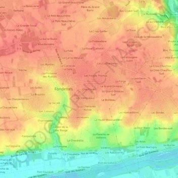
Name: Clos Poulet topographic map, elevation, terrain.
Average elevation: 81 m
Minimum elevation: 39 m
Maximum elevation: 103 m
Other topographic maps
Click on a map to view its topography, its elevation and its terrain.
La Fontaine
France > Centre-Val de Loire > Indre-et-Loire > Fondettes
La Fontaine, Fondettes, Tours, Indre-et-Loire, Centre-Val de Loire, France métropolitaine, 37230, France
Average elevation: 67 m
La Morandière
France > Centre-Val de Loire > Indre-et-Loire > Fondettes
La Morandière, Fondettes, Tours, Indre-et-Loire, Centre-Val de Loire, France métropolitaine, 37230, France
Average elevation: 89 m
Les Cochardières
France > Centre-Val de Loire > Indre-et-Loire > Fondettes
Les Cochardières, Fondettes, Tours, Indre-et-Loire, Centre-Val de Loire, France métropolitaine, 37230, France
Average elevation: 85 m
La Forge
France > Centre-Val de Loire > Indre-et-Loire > Fondettes
La Forge, Fondettes, Tours, Indre-et-Loire, Centre-Val de Loire, France métropolitaine, 37230, France
Average elevation: 80 m
La Grosse Pierre
France > Centre-Val de Loire > Indre-et-Loire > Fondettes
La Grosse Pierre, Fondettes, Arrondissement de Tours, Indre-et-Loire, Centre-Val de Loire, France métropolitaine, 37230, France
Average elevation: 91 m
Les Clerisseaux
France > Centre-Val de Loire > Indre-et-Loire > Fondettes
Les Clerisseaux, Fondettes, Arrondissement de Tours, Indre-et-Loire, Centre-Val de Loire, France métropolitaine, 37230, France
Average elevation: 80 m
Gannay
France > Centre-Val de Loire > Indre-et-Loire > Fondettes
Gannay, Fondettes, Arrondissement de Tours, Indre-et-Loire, Centre-Val de Loire, France métropolitaine, 37230, France
Average elevation: 68 m
La Chevalette-Sud
France > Centre-Val de Loire > Indre-et-Loire > Fondettes
La Chevalette-Sud, Fondettes, Arrondissement de Tours, Indre-et-Loire, Centre-Val de Loire, France métropolitaine, 37230, France
Average elevation: 64 m
Moulin des Roches
France > Centre-Val de Loire > Indre-et-Loire > Fondettes
Moulin des Roches, Fondettes, Arrondissement de Tours, Indre-et-Loire, Centre-Val de Loire, France métropolitaine, 37230, France
Average elevation: 66 m
Le Château de la Plaine
France > Centre-Val de Loire > Indre-et-Loire > Fondettes
Le Château de la Plaine, Fondettes, Arrondissement de Tours, Indre-et-Loire, Centre-Val de Loire, France métropolitaine, 37230, France
Average elevation: 72 m
La Fontaine des Ruettes
France > Centre-Val de Loire > Indre-et-Loire > Fondettes
La Fontaine des Ruettes, Fondettes, Tours, Indre-et-Loire, Centre-Val de Loire, France métropolitaine, 37230, France
Average elevation: 88 m
Le Bourg
France > Centre-Val de Loire > Indre-et-Loire > Fondettes
Le Bourg, Fondettes, Tours, Indre-et-Loire, Centre-Val de Loire, France métropolitaine, 37230, France
Average elevation: 83 m
Les Chairières
France > Centre-Val de Loire > Indre-et-Loire > Fondettes
Les Chairières, Fondettes, Tours, Indre-et-Loire, Centre-Val de Loire, France métropolitaine, 37230, France
Average elevation: 94 m
La Joncherie-sud
France > Centre-Val de Loire > Indre-et-Loire > Fondettes > La Joncherie-sud
La Joncherie-sud, Fondettes, Arrondissement de Tours, Indre-et-Loire, Centre-Val de Loire, France métropolitaine, 37230, France
Average elevation: 78 m
Mazère
France > Centre-Val de Loire > Indre-et-Loire > Fondettes > Mazère
Mazère, Fondettes, Arrondissement de Tours, Indre-et-Loire, Centre-Val de Loire, France métropolitaine, 37230, France
Average elevation: 91 m
Le Val Joli
France > Centre-Val de Loire > Indre-et-Loire > Fondettes > Le Val Joli
Le Val Joli, Fondettes, Tours, Indre-et-Loire, Centre-Val de Loire, France métropolitaine, 37230, France
Average elevation: 80 m
La Brosse
France > Centre-Val de Loire > Indre-et-Loire > Fondettes > La Brosse
La Brosse, Fondettes, Tours, Indre-et-Loire, Centre-Val de Loire, France métropolitaine, 37230, France
Average elevation: 94 m
Tréché
France > Centre-Val de Loire > Indre-et-Loire > Fondettes > Tréché
Tréché, Fondettes, Tours, Indre-et-Loire, Centre-Val de Loire, France métropolitaine, 37230, France
Average elevation: 90 m
La Petite Bruzette
France > Centre-Val de Loire > Indre-et-Loire > Fondettes
La Petite Bruzette, Fondettes, Tours, Indre-et-Loire, Centre-Val de Loire, France métropolitaine, 37230, France
Average elevation: 85 m