
Make a donation
Gear up for your next adventure:
As an Amazon Associate, this site earns from qualifying purchases at no extra cost to you.
Arnsberg topographic map
Click on the map to display elevation.
Make a donation
Gear up for your next adventure:
As an Amazon Associate, this site earns from qualifying purchases at no extra cost to you.
About this map
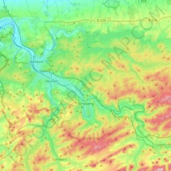
Name: Arnsberg topographic map, elevation, terrain.
Location: Arnsberg, Hochsauerlandkreis, North Rhine-Westphalia, Germany (51.35475 7.86403 51.49133 8.21026)
Average elevation: 281 m
Minimum elevation: 137 m
Maximum elevation: 578 m
Make a donation
Gear up for your next adventure:
As an Amazon Associate, this site earns from qualifying purchases at no extra cost to you.
Other topographic maps
Click on a map to view its topography, its elevation and its terrain.
Ruhrquelle
Germany > North Rhine-Westphalia > Hochsauerlandkreis > Winterberg > Grönebach
Average elevation: 645 m
Lenneplätze
Germany > North Rhine-Westphalia > Hochsauerlandkreis > Winterberg > Neuastenberg
Average elevation: 699 m
Gellinghausen
Germany > North Rhine-Westphalia > Hochsauerlandkreis > Schmallenberg > Westernbödefeld
Average elevation: 565 m
Make a donation
Gear up for your next adventure:
As an Amazon Associate, this site earns from qualifying purchases at no extra cost to you.
Neuastenberg
Germany > North Rhine-Westphalia > Hochsauerlandkreis > Winterberg
Average elevation: 685 m
Altastenberg
Germany > North Rhine-Westphalia > Hochsauerlandkreis > Winterberg
Average elevation: 708 m
Make a donation
Gear up for your next adventure:
As an Amazon Associate, this site earns from qualifying purchases at no extra cost to you.
Niedersfeld
Germany > North Rhine-Westphalia > Hochsauerlandkreis > Winterberg
Average elevation: 655 m
Make a donation
Gear up for your next adventure:
As an Amazon Associate, this site earns from qualifying purchases at no extra cost to you.
Wormbach
Germany > North Rhine-Westphalia > Hochsauerlandkreis > Schmallenberg
Average elevation: 434 m
Hachen
Germany > North Rhine-Westphalia > Hochsauerlandkreis > Sundern > Hachen
Average elevation: 293 m
Make a donation
Gear up for your next adventure:
As an Amazon Associate, this site earns from qualifying purchases at no extra cost to you.