
Gemeinde Bad Pirawarth topographic map
Interactive map
Click on the map to display elevation.
About this map
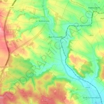
Name: Gemeinde Bad Pirawarth topographic map, elevation, terrain.
Average elevation: 214 m
Minimum elevation: 162 m
Maximum elevation: 279 m
Other topographic maps
Click on a map to view its topography, its elevation and its terrain.
Kollnbrunn
Österreich > Niederösterreich > Bezirk Gänserndorf > Gemeinde Bad Pirawarth > Kollnbrunn
Kollnbrunn, Gemeinde Bad Pirawarth, Bezirk Gänserndorf, Niederösterreich, 2222, Österreich
Average elevation: 211 m