
Make a donation
Gear up for your next adventure:
As an Amazon Associate, this site earns from qualifying purchases at no extra cost to you.
Meran - Merano topographic map
Click on the map to display elevation.
Make a donation
Gear up for your next adventure:
As an Amazon Associate, this site earns from qualifying purchases at no extra cost to you.
Meran - Merano
The average daily temperatures in summer in Merano lie between 27 and 30 °C, while at night temperatures usually drop to between 12 and 15 °C. The average daily temperatures in winter lie between 6 and 10 °C, while at night temperatures usually drop to between -4 and -2 °C. The wettest month is August with 96 mm, while the driest is February with only 25 mm. This data was measured at the weather station Merano/Gratsch at an altitude of 333 metres between 1983 and 2017.
Make a donation
Gear up for your next adventure:
As an Amazon Associate, this site earns from qualifying purchases at no extra cost to you.
About this map
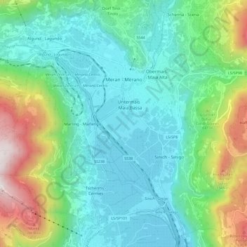
Name: Meran - Merano topographic map, elevation, terrain.
Average elevation: 635 m
Minimum elevation: 255 m
Maximum elevation: 1,790 m
Make a donation
Gear up for your next adventure:
As an Amazon Associate, this site earns from qualifying purchases at no extra cost to you.
Other topographic maps
Click on a map to view its topography, its elevation and its terrain.
Saslonch - Langkofel - Sassolungo
Italy > Trentino – Alto Adige/Südtirol > South Tyrol > Sëlva - Wolkenstein - Selva di Val Gardena
Average elevation: 2,320 m
Graun im Vinschgau - Curon Venosta
Italy > Trentino – Alto Adige/Südtirol > South Tyrol > Graun - Curon Venosta
Average elevation: 1,794 m