Geolocate

Graun im Vinschgau - Curon Venosta topographic map

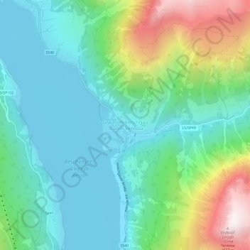
Click on the map to display elevation.

About this map

Name: Graun im Vinschgau - Curon Venosta topographic map, elevation, terrain.

Location: Graun im Vinschgau - Curon Venosta, Graun - Curon Venosta, Vinschgau - Val Venosta, South Tyrol, Trentino – Alto Adige/Südtirol, 39027, Italy (46.78866 10.52144 46.82866 10.56144)

Average elevation: 1,794 m

Minimum elevation: 1,481 m

Maximum elevation: 2,646 m

Gear up for your next adventure:

🪶Ultralight Tents - Lightweight shelters for hikers
🎒Day Packs - Perfect packs for day trips
🧦Hiking Socks - Comfortable socks to prevent blisters
🌲Survival Gear - Equipment for outdoor survival situations
📚Travel Books Ireland - Best travel books for Irish exploration

As an Amazon Associate, this site earns from qualifying purchases at no extra cost to you.