
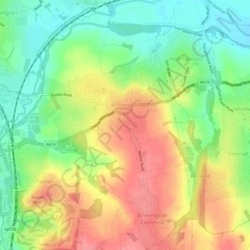
Brimington CP topographic map
Interactive map
Click on the map to display elevation.
About this map
Name: Brimington CP topographic map, elevation, terrain.
Average elevation: 95 m
Minimum elevation: 54 m
Maximum elevation: 139 m
Other topographic maps
Click on a map to view its topography, its elevation and its terrain.
Netherthorpe Flash
United Kingdom > England > Derbyshire > Chesterfield > Norbriggs
Netherthorpe Flash, Poolsbrook, Staveley CP, Norbriggs, Chesterfield, Derbyshire, England, United Kingdom
Average elevation: 66 m
Barrow Hill
United Kingdom > England > Derbyshire > Chesterfield
Barrow Hill, Chesterfield, Derbyshire, England, S43 2PZ, United Kingdom
Average elevation: 82 m
Inkersall
United Kingdom > England > Derbyshire > Chesterfield > Inkersall Green
Inkersall, Staveley CP, Inkersall Green, Chesterfield, Derbyshire, England, S43 3YH, United Kingdom
Average elevation: 87 m
Barlow Brook
United Kingdom > England > Derbyshire > Chesterfield > Barlow
Barlow Brook, Dunston, Barlow, Chesterfield, Derbyshire, East Midlands, England, S41 9RT, United Kingdom
Average elevation: 113 m
Mastin Moor
United Kingdom > England > Derbyshire > Chesterfield
Mastin Moor, Chesterfield, Derbyshire, England, S43 3BD, United Kingdom
Average elevation: 82 m
Hasland
United Kingdom > England > Derbyshire > Chesterfield
Hasland, Chesterfield, Derbyshire, England, S41 0LN, United Kingdom
Average elevation: 107 m
Birdholme
United Kingdom > England > Derbyshire > Chesterfield
Birdholme, Chesterfield, Derbyshire, England, S40 2EU, United Kingdom
Average elevation: 109 m
Tapton
United Kingdom > England > Derbyshire > Chesterfield
Tapton, Chesterfield, Derbyshire, England, S41 0TL, United Kingdom
Average elevation: 100 m