Geolocate

Fairburn topographic map

Click on the map to display elevation.

About this map

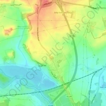
Name: Fairburn topographic map, elevation, terrain.

Location: Fairburn, Selby, North Yorkshire, England, United Kingdom (53.73501 -1.31535 53.76261 -1.26536)

Average elevation: 31 m

Minimum elevation: 7 m

Maximum elevation: 64 m

Other topographic maps

Click on a map to view its topography, its elevation and its terrain.

Lund

United Kingdom > England > North Yorkshire > Selby

Average elevation: 6 m

Ryther

United Kingdom > England > North Yorkshire > Selby

Average elevation: 8 m

Monk Fryston

United Kingdom > England > North Yorkshire > Selby

Average elevation: 14 m

Newton Kyme

United Kingdom > England > North Yorkshire > Selby

Average elevation: 21 m

Brayton

United Kingdom > England > North Yorkshire > Selby

Average elevation: 8 m

Gear up for your next adventure:

📟Handheld Altimeters - Track elevation changes and weather patterns accurately
Ultralight Hiking Tents - Compact shelters for multi-day wild camping in Ireland
🧢Hiking Hats & Caps - Protective headwear for sun and rain
🧊Winter Boot Traction - Grip for icy paths in the Mourne or Derryveagh mountains
🔥Compact Camping Stoves - Fast-boil stoves for trail-side meals and coffee

As an Amazon Associate, this site earns from qualifying purchases at no extra cost to you.