
Make a donation
Gear up for your next adventure:
As an Amazon Associate, this site earns from qualifying purchases at no extra cost to you.
Eton topographic map
Click on the map to display elevation.
Make a donation
Gear up for your next adventure:
As an Amazon Associate, this site earns from qualifying purchases at no extra cost to you.
About this map
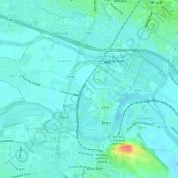
Name: Eton topographic map, elevation, terrain.
Average elevation: 23 m
Minimum elevation: 15 m
Maximum elevation: 64 m
Make a donation
Gear up for your next adventure:
As an Amazon Associate, this site earns from qualifying purchases at no extra cost to you.
Other topographic maps
Click on a map to view its topography, its elevation and its terrain.
Windsor Marina
United Kingdom > England > Royal Borough of Windsor and Maidenhead > Oakley Green
Average elevation: 26 m
Silwood Park
United Kingdom > England > Royal Borough of Windsor and Maidenhead > Beggar's Bush
Average elevation: 61 m
Make a donation
Gear up for your next adventure:
As an Amazon Associate, this site earns from qualifying purchases at no extra cost to you.
Braywoodside
United Kingdom > England > Royal Borough of Windsor and Maidenhead
Average elevation: 43 m
Sunninghill
United Kingdom > England > Royal Borough of Windsor and Maidenhead
Average elevation: 67 m
Magna Carta Island
United Kingdom > England > Royal Borough of Windsor and Maidenhead > Wraysbury
Average elevation: 32 m
Make a donation
Gear up for your next adventure:
As an Amazon Associate, this site earns from qualifying purchases at no extra cost to you.
Cookham Dean
United Kingdom > England > Royal Borough of Windsor and Maidenhead
Average elevation: 50 m
Bridge Gardens
United Kingdom > England > Royal Borough of Windsor and Maidenhead > Maidenhead
Average elevation: 30 m
Upton Court Park
United Kingdom > England > Royal Borough of Windsor and Maidenhead > Slough
Average elevation: 23 m
Make a donation
Gear up for your next adventure:
As an Amazon Associate, this site earns from qualifying purchases at no extra cost to you.
Formosa Island
United Kingdom > England > Royal Borough of Windsor and Maidenhead > Cookham
Average elevation: 48 m
Burchett's Green
United Kingdom > England > Royal Borough of Windsor and Maidenhead > Hurley
Average elevation: 68 m
Windsor Castle
United Kingdom > England > Royal Borough of Windsor and Maidenhead > Windsor > Clewer Village
Average elevation: 23 m
Make a donation
Gear up for your next adventure:
As an Amazon Associate, this site earns from qualifying purchases at no extra cost to you.
Oakley Green
United Kingdom > England > Royal Borough of Windsor and Maidenhead
Average elevation: 37 m
Cookham Rise
United Kingdom > England > Royal Borough of Windsor and Maidenhead
Average elevation: 44 m
Make a donation
Gear up for your next adventure:
As an Amazon Associate, this site earns from qualifying purchases at no extra cost to you.
Sunninghill
United Kingdom > England > Royal Borough of Windsor and Maidenhead
Average elevation: 67 m
Cookham Rise
United Kingdom > England > Royal Borough of Windsor and Maidenhead
Average elevation: 44 m
Windsor Castle
United Kingdom > England > Royal Borough of Windsor and Maidenhead > Windsor > Clewer Village
Average elevation: 23 m
Windsor Castle
United Kingdom > England > Royal Borough of Windsor and Maidenhead > Windsor > Clewer Village
Average elevation: 23 m
Make a donation
Gear up for your next adventure:
As an Amazon Associate, this site earns from qualifying purchases at no extra cost to you.
Windsor Castle
United Kingdom > England > Royal Borough of Windsor and Maidenhead > Windsor > Clewer Village
Average elevation: 23 m
Cookham Dean
United Kingdom > England > Royal Borough of Windsor and Maidenhead
Average elevation: 50 m
Make a donation
Gear up for your next adventure:
As an Amazon Associate, this site earns from qualifying purchases at no extra cost to you.