
Make a donation
Gear up for your next adventure:
As an Amazon Associate, this site earns from qualifying purchases at no extra cost to you.
Bhanu topographic map
Click on the map to display elevation.
Make a donation
Gear up for your next adventure:
As an Amazon Associate, this site earns from qualifying purchases at no extra cost to you.
About this map
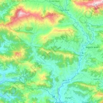
Name: Bhanu topographic map, elevation, terrain.
Location: Bhanu, Tanahun, Gandaki Province, Nepal (27.95213 84.31018 28.12954 84.47769)
Average elevation: 684 m
Minimum elevation: 354 m
Maximum elevation: 1,658 m
Make a donation
Gear up for your next adventure:
As an Amazon Associate, this site earns from qualifying purchases at no extra cost to you.
Other topographic maps
Click on a map to view its topography, its elevation and its terrain.
Bhimad
Nepal > Gandaki Province > Tanahun
Rangrung is famous for its altitude, accessing panoramic views of the broad Himalayan range. Hill Tower with telescope facilities will be constructed in the near future. This is popular for the resorts and overnight stayers. It has enormous potential for paragliding, this area is also famous for biodiversity.…
Average elevation: 544 m
Make a donation
Gear up for your next adventure:
As an Amazon Associate, this site earns from qualifying purchases at no extra cost to you.
Make a donation
Gear up for your next adventure:
As an Amazon Associate, this site earns from qualifying purchases at no extra cost to you.
Make a donation
Gear up for your next adventure:
As an Amazon Associate, this site earns from qualifying purchases at no extra cost to you.