
Green Mountain topographic map
Interactive map
Click on the map to display elevation.
About this map
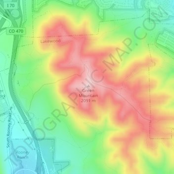
Name: Green Mountain topographic map, elevation, terrain.
Average elevation: 1,940 m
Minimum elevation: 1,815 m
Maximum elevation: 2,087 m
Other topographic maps
Click on a map to view its topography, its elevation and its terrain.
Lakewood
United States > Colorado > Jefferson County > Lakewood
Lakewood, Jefferson County, Colorado, United States
Average elevation: 1,717 m