
Make a donation
Gear up for your next adventure:
As an Amazon Associate, this site earns from qualifying purchases at no extra cost to you.
Quaker Springs topographic map
Click on the map to display elevation.
Make a donation
Gear up for your next adventure:
As an Amazon Associate, this site earns from qualifying purchases at no extra cost to you.
About this map
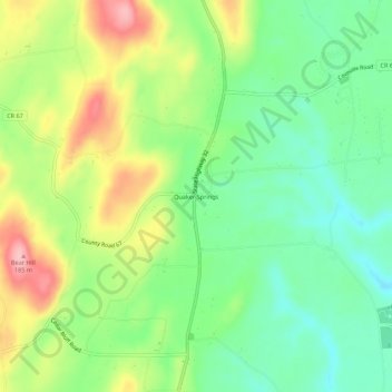
Name: Quaker Springs topographic map, elevation, terrain.
Average elevation: 102 m
Minimum elevation: 45 m
Maximum elevation: 188 m
Make a donation
Gear up for your next adventure:
As an Amazon Associate, this site earns from qualifying purchases at no extra cost to you.
Other topographic maps
Click on a map to view its topography, its elevation and its terrain.
Saratoga Spa State Park
United States > New York > Saratoga County > City of Saratoga Springs
Average elevation: 91 m
Country Knolls
United States > New York > Saratoga County > Town of Clifton Park
Average elevation: 86 m
Make a donation
Gear up for your next adventure:
As an Amazon Associate, this site earns from qualifying purchases at no extra cost to you.
North Ballston Spa
United States > New York > Saratoga County > Town of Milton
Average elevation: 106 m
Make a donation
Gear up for your next adventure:
As an Amazon Associate, this site earns from qualifying purchases at no extra cost to you.
Village of Round Lake
United States > New York > Saratoga County > Town of Malta
Average elevation: 62 m