
Panlong District topographic map
Interactive map
Click on the map to display elevation.
About this map
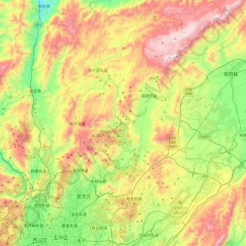
Name: Panlong District topographic map, elevation, terrain.
Location: Panlong District, Kunming, Yunnan, China (25.03038 102.69589 25.46294 103.03503)
Average elevation: 2,138 m
Minimum elevation: 1,650 m
Maximum elevation: 2,806 m
Other topographic maps
Click on a map to view its topography, its elevation and its terrain.
Wuhua District
Wuhua District, Kunming, Yunnan, China
Average elevation: 2,104 m
Jinchen Subdistrict
China > Yunnan > Kunming > Jinchen Subdistrict
Jinchen Subdistrict, Panlong District, Kunming, Yunnan, China
Average elevation: 1,918 m