
North 24 Parganas topographic map
Interactive map
Click on the map to display elevation.
About this map
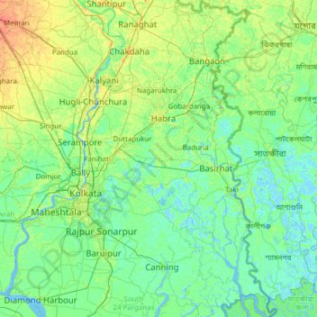
Name: North 24 Parganas topographic map, elevation, terrain.
Location: North 24 Parganas, West Bengal, India (22.12918 88.32947 23.25661 89.09645)
Average elevation: 6 m
Minimum elevation: -4 m
Maximum elevation: 25 m
Other topographic maps
Click on a map to view its topography, its elevation and its terrain.
Bidhannagar
India > West Bengal > Bhangar - II
Bidhannagar, Bhangar - II, South 24 Parganas, West Bengal, 700064, India
Average elevation: 5 m
Sandakphu
India > West Bengal > Darjeeling Pulbazar
Sandakphu, Darjeeling Pulbazar, Darjeeling, West Bengal, India
Average elevation: 3,285 m
Darjeeling
India > West Bengal > Darjeeling Pulbazar > Darjeeling
Darjeeling, Darjeeling Pulbazar, Darjeeling, West Bengal, 734101, India
Average elevation: 1,324 m
Magrahat
India > West Bengal > Magrahat
Magrahat, Magrahat - II, South 24 Parganas, West Bengal, India
Average elevation: 4 m
Bardhaman
India > West Bengal > Burdwan - I > Bardhaman
Bardhaman, Burdwan - I, Paschim Bardhaman, West Bengal, 713102, India
Average elevation: 30 m