
Dunmore topographic map
Interactive map
Click on the map to display elevation.
About this map
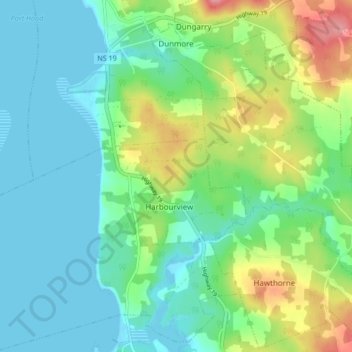
Name: Dunmore topographic map, elevation, terrain.
Average elevation: 28 m
Minimum elevation: -1 m
Maximum elevation: 100 m
Other topographic maps
Click on a map to view its topography, its elevation and its terrain.
Mabou Harbour
Canada > Nova Scotia > Municipality of the County of Inverness > West Mabou
Mabou Harbour, West Mabou, Municipality of the County of Inverness, Inverness County, Nova Scotia, Canada
Average elevation: 51 m
Big Harbour Island
Canada > Nova Scotia > Municipality of the County of Inverness
Big Harbour Island, Municipality of the County of Inverness, Inverness County, Nova Scotia, Canada
Average elevation: 3 m
Gull Island
Canada > Nova Scotia > Municipality of the County of Inverness > Big Harbour Island
Gull Island, Big Harbour Island, Municipality of the County of Inverness, Inverness County, Nova Scotia, Canada
Average elevation: 74 m