
Make a donation
Gear up for your next adventure:
As an Amazon Associate, this site earns from qualifying purchases at no extra cost to you.
Berg topographic map
Click on the map to display elevation.
Make a donation
Gear up for your next adventure:
As an Amazon Associate, this site earns from qualifying purchases at no extra cost to you.
About this map
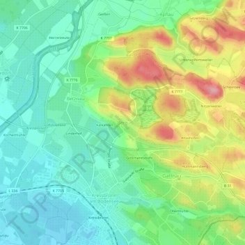
Name: Berg topographic map, elevation, terrain.
Average elevation: 443 m
Minimum elevation: 396 m
Maximum elevation: 530 m
Make a donation
Gear up for your next adventure:
As an Amazon Associate, this site earns from qualifying purchases at no extra cost to you.
Other topographic maps
Click on a map to view its topography, its elevation and its terrain.
Friedrichshafen
Germany > Baden-Württemberg > Bodenseekreis
Friedrichshafen is located on a gently curved bay on the north shore of Lake Constance and on the southwest edge of the Schussen. The city is over an altitude of 395.2 m above sea level. NHH on the shores of Lake Constance up to 501.6 m in Ailingen. The core city is located not far to the west of the…
Average elevation: 441 m
Make a donation
Gear up for your next adventure:
As an Amazon Associate, this site earns from qualifying purchases at no extra cost to you.