
Make a donation
Gear up for your next adventure:
As an Amazon Associate, this site earns from qualifying purchases at no extra cost to you.
Bad Laasphe topographic map
Click on the map to display elevation.
Make a donation
Gear up for your next adventure:
As an Amazon Associate, this site earns from qualifying purchases at no extra cost to you.
Bad Laasphe
The highest elevation in the municipal area rises to 694 m. It lies southwest of the main town at the outlying centre of Heiligenborn.
Make a donation
Gear up for your next adventure:
As an Amazon Associate, this site earns from qualifying purchases at no extra cost to you.
About this map
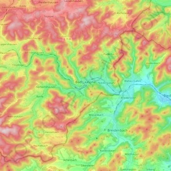
Name: Bad Laasphe topographic map, elevation, terrain.
Average elevation: 464 m
Minimum elevation: 272 m
Maximum elevation: 672 m
Make a donation
Gear up for your next adventure:
As an Amazon Associate, this site earns from qualifying purchases at no extra cost to you.
Other topographic maps
Click on a map to view its topography, its elevation and its terrain.
Obernberg
Germany > North Rhine-Westphalia > Kreis Siegen-Wittgenstein > Bad Laasphe
Average elevation: 488 m
Rüppershausen
Germany > North Rhine-Westphalia > Kreis Siegen-Wittgenstein > Bad Laasphe
Average elevation: 497 m
NSG Erzebachtal
Germany > North Rhine-Westphalia > Kreis Siegen-Wittgenstein > Kreuztal > Fellinghausen
Average elevation: 329 m
Make a donation
Gear up for your next adventure:
As an Amazon Associate, this site earns from qualifying purchases at no extra cost to you.
Heisberg
Germany > North Rhine-Westphalia > Kreis Siegen-Wittgenstein > Freudenberg
Average elevation: 338 m
Siegen
Germany > North Rhine-Westphalia > Kreis Siegen-Wittgenstein > Siegen
The city's total land area is roughly 115 km2 (44 sq mi). Its greatest east-west span is about 12 km (7 mi), and its greatest north-south span is about 12 km (7 mi). City limits are 48 km (30 mi) long. Siegen lies at a median elevation of 290 m (951 ft) above sea level. The city's greatest elevation is the…
Average elevation: 401 m