
Thank you for supporting this site ❤️
Make a donation
Make a donation
Gear up for your next adventure:
As an Amazon Associate, this site earns from qualifying purchases at no extra cost to you.
Castheddu/Castelsardo topographic map
Click on the map to display elevation.
Thank you for supporting this site ❤️
Make a donation
Make a donation
Gear up for your next adventure:
As an Amazon Associate, this site earns from qualifying purchases at no extra cost to you.
About this map
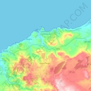
Name: Castheddu/Castelsardo topographic map, elevation, terrain.
Location: Castheddu/Castelsardo, Sassari, Sardinia, 07031, Italy (40.86529 8.63078 40.91940 8.80059)
Average elevation: 149 m
Minimum elevation: -1 m
Maximum elevation: 530 m
Thank you for supporting this site ❤️
Make a donation
Make a donation
Gear up for your next adventure:
As an Amazon Associate, this site earns from qualifying purchases at no extra cost to you.