
Thank you for supporting this site ❤️
Make a donation
Make a donation
Gear up for your next adventure:
As an Amazon Associate, this site earns from qualifying purchases at no extra cost to you.
Ona topographic map
Click on the map to display elevation.
Thank you for supporting this site ❤️
Make a donation
Make a donation
Gear up for your next adventure:
As an Amazon Associate, this site earns from qualifying purchases at no extra cost to you.
About this map
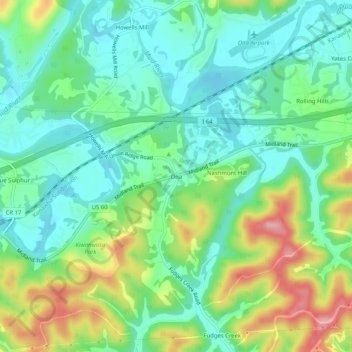
Name: Ona topographic map, elevation, terrain.
Location: Ona, Cabell County, West Virginia, 25545, United States (38.40481 -82.23320 38.44481 -82.19320)
Average elevation: 207 m
Minimum elevation: 163 m
Maximum elevation: 300 m
Thank you for supporting this site ❤️
Make a donation
Make a donation
Gear up for your next adventure:
As an Amazon Associate, this site earns from qualifying purchases at no extra cost to you.
Other topographic maps
Click on a map to view its topography, its elevation and its terrain.
Pea Ridge
United States > West Virginia > Cabell County > Barboursville > Tallwood Acres
Average elevation: 197 m