
Rutland Island topographic map
Interactive map
Click on the map to display elevation.
About this map
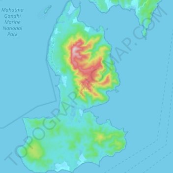
Name: Rutland Island topographic map, elevation, terrain.
Location: Rutland Island, Andaman and Nicobar Islands, India (11.34637 92.58128 11.51675 92.69319)
Average elevation: 29 m
Minimum elevation: -1 m
Maximum elevation: 419 m
Other topographic maps
Click on a map to view its topography, its elevation and its terrain.
North and Middle Andaman
India > Andaman and Nicobar Islands
North and Middle Andaman, Andaman and Nicobar Islands, 744210, India
Average elevation: 4 m
South Andaman
India > Andaman and Nicobar Islands
South Andaman, Andaman and Nicobar Islands, India
Average elevation: 3 m