
Cotswold topographic map
Interactive map
Click on the map to display elevation.
About this map
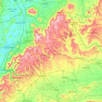
Name: Cotswold topographic map, elevation, terrain.
Average elevation: 118 m
Minimum elevation: 6 m
Maximum elevation: 328 m
Other topographic maps
Click on a map to view its topography, its elevation and its terrain.
Batsford
Royaume-Uni > Angleterre > Cotswold > Batsford
Batsford, Cotswold, Gloucestershire, South West England, Angleterre, Royaume-Uni
Average elevation: 152 m
Bledington
Royaume-Uni > Angleterre > Cotswold > Bledington
Bledington, Cotswold, Gloucestershire, South West England, Angleterre, OX7 6XQ, Royaume-Uni
Average elevation: 118 m
Longborough
Royaume-Uni > Angleterre > Cotswold > Longborough
Longborough, Cotswold, Gloucestershire, South West England, Angleterre, GL56 0QQ, Royaume-Uni
Average elevation: 179 m
Didmarton
Royaume-Uni > Angleterre > Cotswold > Didmarton
Didmarton, Cotswold, Gloucestershire, South West England, Angleterre, GL9 1, Royaume-Uni
Average elevation: 141 m