
Make a donation
Gear up for your next adventure:
As an Amazon Associate, this site earns from qualifying purchases at no extra cost to you.
Little Water topographic map
Click on the map to display elevation.
Make a donation
Gear up for your next adventure:
As an Amazon Associate, this site earns from qualifying purchases at no extra cost to you.
About this map
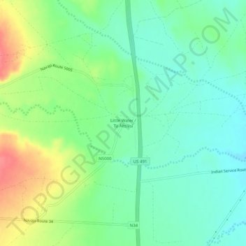
Name: Little Water topographic map, elevation, terrain.
Average elevation: 1,702 m
Minimum elevation: 1,678 m
Maximum elevation: 1,747 m
Make a donation
Gear up for your next adventure:
As an Amazon Associate, this site earns from qualifying purchases at no extra cost to you.
Other topographic maps
Click on a map to view its topography, its elevation and its terrain.
Navajo Lake State Park
United States > New Mexico > San Juan County > Navajo Dam
Average elevation: 1,966 m
Lake Farmington Recreation Area
United States > New Mexico > San Juan County > Farmington
Average elevation: 1,723 m
Make a donation
Gear up for your next adventure:
As an Amazon Associate, this site earns from qualifying purchases at no extra cost to you.