
La Voie topographic map
Interactive map
Click on the map to display elevation.
About this map
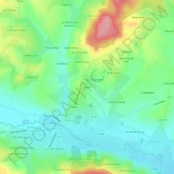
Name: La Voie topographic map, elevation, terrain.
Average elevation: 154 m
Minimum elevation: 116 m
Maximum elevation: 232 m
Other topographic maps
Click on a map to view its topography, its elevation and its terrain.
Rémalard
France > Normandie > Orne > Rémalard en Perche
Rémalard, Rémalard en Perche, Mortagne-au-Perche, Orne, Normandie, France métropolitaine, 61110, France
Average elevation: 177 m
61110
France > Normandie > Orne > Rémalard en Perche > La Guénetterie
61110, La Guénetterie, Dorceau, Rémalard en Perche, Mortagne-au-Perche, Orne, Normandie, France métropolitaine, France
Average elevation: 159 m