
Thank you for supporting this site ❤️
Make a donation
Make a donation
Gear up for your next adventure:
As an Amazon Associate, this site earns from qualifying purchases at no extra cost to you.
Baraka topographic map
Click on the map to display elevation.
Thank you for supporting this site ❤️
Make a donation
Make a donation
Gear up for your next adventure:
As an Amazon Associate, this site earns from qualifying purchases at no extra cost to you.
About this map
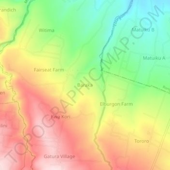
Name: Baraka topographic map, elevation, terrain.
Location: Baraka, Elburgon ward, Molo, Nakuru, Rift Valley, Kenya (-0.26766 35.78155 -0.22766 35.82155)
Average elevation: 2,215 m
Minimum elevation: 2,047 m
Maximum elevation: 2,379 m
Thank you for supporting this site ❤️
Make a donation
Make a donation
Gear up for your next adventure:
As an Amazon Associate, this site earns from qualifying purchases at no extra cost to you.