
Steyr topographic map
Interactive map
Click on the map to display elevation.
About this map
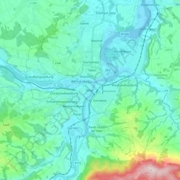
Name: Steyr topographic map, elevation, terrain.
Location: Steyr, Oberösterreich, 4407, Österreich (47.99900 14.37913 48.07900 14.45913)
Average elevation: 378 m
Minimum elevation: 279 m
Maximum elevation: 802 m
Steyr liegt auf 310 m Höhe im Alpenvorland an der Grenze zu Niederösterreich. Die Ausdehnung beträgt von Nord nach Süd 7 km, von West nach Ost 7,3 km. 2,8 % der Fläche sind bewaldet, 11,1 % der Fläche landwirtschaftlich genutzt.
Other topographic maps
Click on a map to view its topography, its elevation and its terrain.
Steyr (Gsangwasser)
Österreich > Oberösterreich > Steyr
Steyr (Gsangwasser), Eisenfeld, Steyr, Oberösterreich, 4400, Österreich
Average elevation: 331 m