
Kitzbühel topographic map
Interactive map
Click on the map to display elevation.
About this map
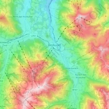
Name: Kitzbühel topographic map, elevation, terrain.
Location: Kitzbühel, Bezirk Kitzbühel, 6370, Österreich (47.39505 12.34109 47.47793 12.50914)
Average elevation: 1,176 m
Minimum elevation: 692 m
Maximum elevation: 1,974 m
Die komplette Liste der Statistik Austria ist in: Topographische Siedlungskennzeichnung nach STAT
Other topographic maps
Click on a map to view its topography, its elevation and its terrain.
Aschau
Aschau, Kirchberg in Tirol, Bezirk Kitzbühel, Österreich
Average elevation: 1,314 m
Kelchsau
Österreich > Bezirk Kitzbühel > Hopfgarten im Brixental
Kelchsau, Hopfgarten im Brixental, Bezirk Kitzbühel, 6361, Österreich
Average elevation: 1,123 m