
Make a donation
Gear up for your next adventure:
As an Amazon Associate, this site earns from qualifying purchases at no extra cost to you.
Mbombela topographic map
Click on the map to display elevation.
Make a donation
Gear up for your next adventure:
As an Amazon Associate, this site earns from qualifying purchases at no extra cost to you.
Mbombela
Nelspruit Airport, located about 9 km (6 mi) south west of the city, is the city's original airport owned and operated by the municipality. There are over a hundred aircraft based at the airport. The majority of the aircraft are privately owned but there are several commercial aircraft based here as well. There are several AMO, fire fighting, charter & training companies based at the airport. The airport is limited in its potential operations by its runway length of 875 m (2870 ft). The topography of the area prohibits expansion.
Make a donation
Gear up for your next adventure:
As an Amazon Associate, this site earns from qualifying purchases at no extra cost to you.
About this map
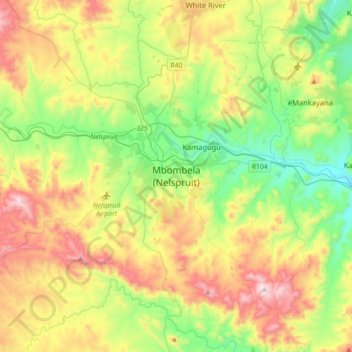
Name: Mbombela topographic map, elevation, terrain.
Average elevation: 842 m
Minimum elevation: 493 m
Maximum elevation: 1,483 m
Make a donation
Gear up for your next adventure:
As an Amazon Associate, this site earns from qualifying purchases at no extra cost to you.
Other topographic maps
Click on a map to view its topography, its elevation and its terrain.
Kanyamazane
South Africa > Mpumalanga > Ehlanzeni District Municipality > Mbombela
Average elevation: 636 m
Blyde River Canyon Nature Reserve
South Africa > Mpumalanga > Ehlanzeni District Municipality > Thaba Chweu Local Municipality
The Mogologolo (1,794 m), Mariepskop (1,944 m) and Hebronberg (1,767 m) massifs are partially included in the reserve. Elevation varies from 560 m to 1,944 m above sea level. Its resort areas are F.H. Odendaal and Swadeni, the latter only accessible from Limpopo province. The area of approximately 29,000…
Average elevation: 1,040 m
Make a donation
Gear up for your next adventure:
As an Amazon Associate, this site earns from qualifying purchases at no extra cost to you.
Umjindi Ward 1
South Africa > Mpumalanga > Ehlanzeni District Municipality > Umjindi Local Municipality
Average elevation: 916 m
Lydenburg
South Africa > Mpumalanga > Ehlanzeni District Municipality > Thaba Chweu Local Municipality
Average elevation: 1,424 m
Kwena Dam
South Africa > Mpumalanga > Ehlanzeni District Municipality > Thaba Chweu Local Municipality
Average elevation: 1,185 m
Make a donation
Gear up for your next adventure:
As an Amazon Associate, this site earns from qualifying purchases at no extra cost to you.
Blyde River
South Africa > Mpumalanga > Ehlanzeni District Municipality
The Motlatse River ("Permanent River"), Blyde River (Afrikaans: Blyderivier "Glad River"), or Umdhlazi River is a river in the Mpumalanga and Limpopo provinces of South Africa. It has a northwards course in steep-sided valleys and ravines of the Mpumalanga Drakensberg, before it enters the lowveld region of…
Average elevation: 930 m
Driekoppies Dam
South Africa > Mpumalanga > Ehlanzeni District Municipality > Nkomazi > Schulzendal
Average elevation: 355 m
Manyeleti
South Africa > Mpumalanga > Ehlanzeni District Municipality > Bushbuckridge
Average elevation: 376 m
Thaba Chweu Local Municipality
South Africa > Mpumalanga > Ehlanzeni District Municipality
Average elevation: 1,207 m
Make a donation
Gear up for your next adventure:
As an Amazon Associate, this site earns from qualifying purchases at no extra cost to you.
Witklip Dam
South Africa > Mpumalanga > Ehlanzeni District Municipality > Thaba Chweu Local Municipality
Average elevation: 1,048 m
Thaba Chweu Local Municipality
South Africa > Mpumalanga > Ehlanzeni District Municipality
Average elevation: 1,207 m
Make a donation
Gear up for your next adventure:
As an Amazon Associate, this site earns from qualifying purchases at no extra cost to you.
Klipkoppie Dam
South Africa > Mpumalanga > Ehlanzeni District Municipality > Mbombela
Average elevation: 973 m
Tekwane North
South Africa > Mpumalanga > Ehlanzeni District Municipality > Mbombela > eMankayana
Average elevation: 771 m
Umgwenya
South Africa > Mpumalanga > Ehlanzeni District Municipality > Thaba Chweu Local Municipality
Average elevation: 1,211 m
MalaMala Game Reserve
South Africa > Mpumalanga > Ehlanzeni District Municipality > Bushbuckridge
Average elevation: 338 m
Make a donation
Gear up for your next adventure:
As an Amazon Associate, this site earns from qualifying purchases at no extra cost to you.
Umbabat Nature Reserve
South Africa > Mpumalanga > Ehlanzeni District Municipality > Bushbuckridge
Average elevation: 343 m
Manyeleti
South Africa > Mpumalanga > Ehlanzeni District Municipality > Bushbuckridge
Average elevation: 376 m
MalaMala Game Reserve
South Africa > Mpumalanga > Ehlanzeni District Municipality > Bushbuckridge
Average elevation: 338 m
Make a donation
Gear up for your next adventure:
As an Amazon Associate, this site earns from qualifying purchases at no extra cost to you.
Marite
South Africa > Mpumalanga > Ehlanzeni District Municipality > Bushbuckridge
Average elevation: 602 m
Umjindi Local Municipality
South Africa > Mpumalanga > Ehlanzeni District Municipality
Average elevation: 1,007 m
Lydenburg
South Africa > Mpumalanga > Ehlanzeni District Municipality > Thaba Chweu Local Municipality
Average elevation: 1,424 m
Kwena Dam
South Africa > Mpumalanga > Ehlanzeni District Municipality > Thaba Chweu Local Municipality
Average elevation: 1,185 m
Make a donation
Gear up for your next adventure:
As an Amazon Associate, this site earns from qualifying purchases at no extra cost to you.
Thaba Chweu Local Municipality
South Africa > Mpumalanga > Ehlanzeni District Municipality
Average elevation: 1,207 m
Longmere Dam
South Africa > Mpumalanga > Ehlanzeni District Municipality > Mbombela > White River Country Estates
Average elevation: 963 m
Klaserie Private Nature Reserve
South Africa > Mpumalanga > Ehlanzeni District Municipality
Average elevation: 395 m
Thaba Chweu Local Municipality
South Africa > Mpumalanga > Ehlanzeni District Municipality
Average elevation: 1,207 m
Make a donation
Gear up for your next adventure:
As an Amazon Associate, this site earns from qualifying purchases at no extra cost to you.