
Make a donation
Gear up for your next adventure:
As an Amazon Associate, this site earns from qualifying purchases at no extra cost to you.
Santa Cruz topographic map
Click on the map to display elevation.
Make a donation
Gear up for your next adventure:
As an Amazon Associate, this site earns from qualifying purchases at no extra cost to you.
About this map
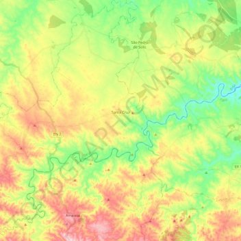
Name: Santa Cruz topographic map, elevation, terrain.
Location: Santa Cruz, Almodôvar, Beja, Portugal (37.34424 -8.06341 37.52491 -7.88800)
Average elevation: 296 m
Minimum elevation: 158 m
Maximum elevation: 477 m
Make a donation
Gear up for your next adventure:
As an Amazon Associate, this site earns from qualifying purchases at no extra cost to you.
Other topographic maps
Click on a map to view its topography, its elevation and its terrain.
Make a donation
Gear up for your next adventure:
As an Amazon Associate, this site earns from qualifying purchases at no extra cost to you.
Vila Nova de São Bento
Portugal > Beja > Vila Nova de São Bento e Vale de Vargo
Average elevation: 233 m
Make a donation
Gear up for your next adventure:
As an Amazon Associate, this site earns from qualifying purchases at no extra cost to you.
Make a donation
Gear up for your next adventure:
As an Amazon Associate, this site earns from qualifying purchases at no extra cost to you.
Vale Pepino
Portugal > Beja > Boavista dos Pinheiros > Boavista dos Pinheiros > Vale Pepino
Average elevation: 77 m
Santa Margarida do Sado
Portugal > Beja > Ferreira do Alentejo > Santa Margarida do Sado
Average elevation: 48 m
Make a donation
Gear up for your next adventure:
As an Amazon Associate, this site earns from qualifying purchases at no extra cost to you.