
Make a donation
Gear up for your next adventure:
As an Amazon Associate, this site earns from qualifying purchases at no extra cost to you.
Alsfeld topographic map
Click on the map to display elevation.
Make a donation
Gear up for your next adventure:
As an Amazon Associate, this site earns from qualifying purchases at no extra cost to you.
Alsfeld
The Pfefferhöhe rest area near Alsfeld is the second highest rest area (in altitude) along the A 5, the and also a popular meeting place.
Make a donation
Gear up for your next adventure:
As an Amazon Associate, this site earns from qualifying purchases at no extra cost to you.
About this map
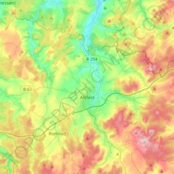
Name: Alsfeld topographic map, elevation, terrain.
Location: Alsfeld, Vogelsbergkreis, Hesse, 36304, Germany (50.69798 9.17093 50.82661 9.46126)
Average elevation: 331 m
Minimum elevation: 220 m
Maximum elevation: 487 m
Make a donation
Gear up for your next adventure:
As an Amazon Associate, this site earns from qualifying purchases at no extra cost to you.
Other topographic maps
Click on a map to view its topography, its elevation and its terrain.