
Parroquia Naiguatá topographic map
Interactive map
Click on the map to display elevation.
About this map
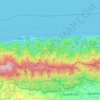
Name: Parroquia Naiguatá topographic map, elevation, terrain.
Average elevation: 560 m
Minimum elevation: -4 m
Maximum elevation: 2,734 m
Other topographic maps
Click on a map to view its topography, its elevation and its terrain.
Cordillera de la Costa
Venezuela > Vargas > Parroquia Naiguatá
Cordillera de la Costa, Parroquia Naiguatá, Municipio Vargas, Vargas, Región Capital, Venezuela
Average elevation: 1,661 m