
Make a donation
Gear up for your next adventure:
As an Amazon Associate, this site earns from qualifying purchases at no extra cost to you.
Tehachapi topographic map
Click on the map to display elevation.
Make a donation
Gear up for your next adventure:
As an Amazon Associate, this site earns from qualifying purchases at no extra cost to you.
Tehachapi
Tehachapi (/təˈhætʃəpi/ ; Kawaiisu: Tihachipia, meaning "hard climb") is a city in Kern County, California, United States, in the Tehachapi Mountains, at an elevation of 3,970 feet (1,210 m), between the San Joaquin Valley and the Mojave Desert. Tehachapi is 35 miles (56 km) east-southeast of Bakersfield, and 20 miles (32 km) west of Mojave. According to the United States Census Bureau, the city has a total area of 10 square miles (26 km2) and a population of 14,414. The Tehachapi area is known for the nearby Tehachapi Loop (a popular railfan site), the Pacific Crest Trail and for the excellent conditions for the aerial sport of gliding.
Make a donation
Gear up for your next adventure:
As an Amazon Associate, this site earns from qualifying purchases at no extra cost to you.
About this map
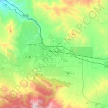
Name: Tehachapi topographic map, elevation, terrain.
Location: Tehachapi, Kern County, California, United States (35.09828 -118.59307 35.15843 -118.39649)
Average elevation: 1,414 m
Minimum elevation: 853 m
Maximum elevation: 2,403 m
Make a donation
Gear up for your next adventure:
As an Amazon Associate, this site earns from qualifying purchases at no extra cost to you.