
Make a donation
Gear up for your next adventure:
As an Amazon Associate, this site earns from qualifying purchases at no extra cost to you.
Rutherford County topographic map
Click on the map to display elevation.
Make a donation
Gear up for your next adventure:
As an Amazon Associate, this site earns from qualifying purchases at no extra cost to you.
About this map
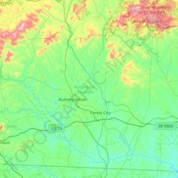
Name: Rutherford County topographic map, elevation, terrain.
Location: Rutherford County, North Carolina, United States (35.18061 -82.28057 35.61360 -81.69187)
Average elevation: 345 m
Minimum elevation: 183 m
Maximum elevation: 964 m
Make a donation
Gear up for your next adventure:
As an Amazon Associate, this site earns from qualifying purchases at no extra cost to you.
Other topographic maps
Click on a map to view its topography, its elevation and its terrain.
Make a donation
Gear up for your next adventure:
As an Amazon Associate, this site earns from qualifying purchases at no extra cost to you.
Cliffdale
United States > North Carolina > Cumberland County > Fayetteville > Cliffdale
Average elevation: 69 m